Sferics Project
Background
Severe weather monitoring has been a personal project for nearly 40 years. The monitoring techniques have progressed from an omnidirectional pulse counter to detailed measurement of pulse shape and relative timing with the appropriate data analysis procedures. The results from each monitoring system have dictated the requirements for the next step. This has been a tedious journey since each step generally required one or more yearly seasons to determine relevant factors for the next step.
Currently, the monitor consists of the crossed loop antenna array, analog amplification and direction conversion hardware, several microprocessors for real time data collection, and personal computers for data analysis. The data accumulation hardware is designed for continuous unattended operation and includes emergency battery power .
Monitoring Parameters
Three parameters (pulse shape, pulse polarity and relative timing) of the electromagnetic radiation are measured with reference to the direction-of-arrival. These measurements have been used to observe changes in the spectral distribution rather than the exact magnitude of the parameter. In general, signal amplitude is disregarded.
The relative timing between a series of events has been the primary monitoring parameter for many years. For this data, each series of three events that occur from the same direction in less than one second is sorted into one of two categories. Either the time between the first and second event is greater or less than the time between the second and third event. In a long series of events, each event will contribute to more than one comparison.
A simple measurement of pulse shape is made by noting the time between the first signal excursion and the next excursion of the opposite polarity. This time is sorted into four categories. In addition, the polarity of the first excursion is accumulated as pulse polarity data. The electrostatic component of the radiation is used for pulse shape measurements and the magnetic component is used for direction determination.
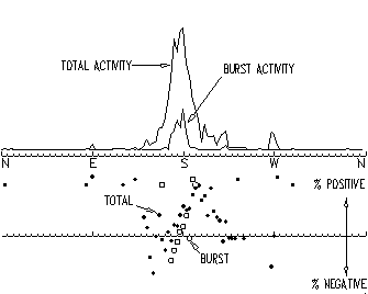
The accumulations are referenced to the signal direction-of-arrival (120 segments or 3 degrees/segment). Periodically, (usually each 5 minutes), the accumulations are analyzed and separated into categories of generate total activity, burst activity, percentage of positive events, percentages of pulse shapes (widths) and a timing factor which is the ratio of the "greater than"/"less than" relative timing accumulators. These summations are further reduced to peak activity descriptors, e.g., bands of activity concentration with reference to direction-of-arrival. Each peak descriptor included direction, activity level (events per time period), timing factor, positive event percentage, and pulse width percentages. This data is the basis for the pattern analysis.
Analysis Procedures
All peak descriptor data are saved on disk for correlation studies at a later time. Raw data is retained in computer memory for up to 8 hours. This data can be saved on disk by keypress or mouse button click. Several formats are available for data analysis. The two most useful are graphical plots of activity direction versus time and activity peak (descriptor data-timing, polarity and shape data) versus time.
The activity direction versus time is not useful for pattern detection but is used to help determine the location of the activity. The peak width change and directional movement is used to estimate the activity location. This procedure is more subjective than analytical but is useful to limit the search for reported severe weather.
The peak tracking format traces a selected peak (weather formation) over a period of time. The event activity is used as criteria for the trace function which finds matching directional peaks from each periodic data record and plots the activity, timing factor, polarity percentage and pulse shape percentages as a function of record (time). This format produces the patterns which are the subject of this paper. During real-time, a peak can be selected by keypresses or mouse "point and click" and tracked for up to 8 hours. Archived data can also be analyzed in a similar manner.
Pattern Observations
Large polarity variations with reference to direction-of-arrival (across a front) are also observed. Reoccurring patterns of the timing factor, polarity, and pulse shape are observed as a function of time. Distance effects (signal strengths and activity rate) are minimized by using graphic plots of distribution factors, e.g., ratios or percentages. Although quantitative data is available, it is seldom used for pattern observation.
These patterns occur over a wide variation of time spans. The timing factor have cyclic variations with periods of nearly an hour. The polarity distribution is observed to both change very slowly throughout the day or change rapidly in a few minutes. Generally, the pulse width distributions are similar to the polarity patterns. Some events have a unique correlation between the polarity and pulse width which will be described. The drawings presented in the following descriptions were constructed from the real data without alteration or modification.
Timing Patterns
The relative timing between events occurring in a short period (less than one second) has been studied for several years. This data is generated from the time between successive events that arrive from the same direction. Each series of three events is used to determine one bit of data. As each event triplet arrive, the time between the first and second is compared to the time between the second and third event. If the time between the first and second is greater than the time between the second and third, one accumulator is advanced. The opposite condition advances a second accumulator. There is an accumulator pair referenced to each of 120 direction channels. If the relative timing between events were truly random, one would expect the two accumulators to be nearly equal (there is some statistical error). When the timing factor (ratio of the two accumulators) is plotted with respect to time, it does not show a flat line, but varies over a wide range.
The timing factor patterns have been compared with severe weather for several years. The earlier timing factor analysis sorted the time-between-events into two categories based on the actual time rather than the current "less than" or "greater than" comparison. This simpler comparison was incorporated after an exposure to Chaos theory which suggests that one event would influence the next event similar to the classical water drop experiment. The patterns from this comparison are very similar to the earlier method of comparison.
The following interpretations are somewhat subjective since the data is from a single monitoring site with limited access to real time weather information. When two or more weather formations are located in the same general direction or the activity is too distant (greater than 500 miles), the confidence of the monitored data is reduced. In many cases, some evidence of the expected patterns are present. After many hours of observation, the following conclusions have been assembled, some objective and some subjective.
In the early stages of the severe weather, the timing factor varies over a wide range in a periodic manner. The period of some of these variations can be nearly an hour. Minutes before severe weather (large hail, funnel cloud, tornado, etc.), the variation becomes much smaller. During the severe weather, the large variation return. The quantity of multiple events also decreases at the time of severe weather.
 Numerous severe weather occurrences have been analyzed with respect to the timing data with varying degrees of correlation. The best example is the Lemont, IL tornado of March 27, 1991. In this case, the timing variation decreased about 35 minutes before the tornado event and remained low until a few minutes before the actual tornado. In addition, the burst activity increased rapidly and then decreased at the same time the timing factor variation increased. From the many observations of other severe occurrences, this seems to be a "picture book" representation. Other observations generally have had one or more of these unique patterns.
The Lemont tornado came from a very rapid buildup. Some severe systems have been observed to build up rapidly and, then, maintain a relatively constant activity level for several hours before the severe weather develops. During this constant activity level, the timing factor can vary of a wide range in a periodic manner. It appears that the severe weather will either occur during the rapid buildup or after several hours of relatively constant activity.
Polarity Patterns
 The event polarities, which are the pulse polarities of the initial signal excursions during an event, are collected and converted to a percentage of total events referenced to the direction-of-arrival. Patterns are observed from both the direction and elapsed time data. At this time, correlation with severe weather is incomplete but several patterns have been observed to repeat.
Many formations show a complete polarity reversal across the formation (reference to direction). The polarity percentage at the maximum activity direction (peak descriptor data) can vary slowly as time passes but the polarity reversal is maintained. The bottom two plots illustrates the polarity distribution for both total and burst activity.
Burst activity polarity percentage appears to follow the total activity but it is suspected that burst polarity percentage may change rapidly at the time of severe weather. One instance was noted where a formation contained two burst activity peaks within a single total activity peak. The two burst peaks were of opposite polarities while the total activity peak indicated the smooth polarity reversal across the formation.
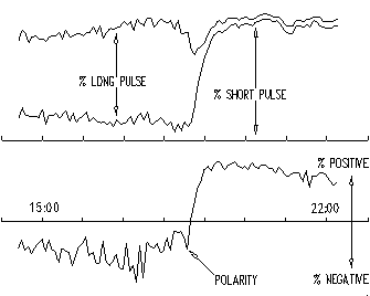 Another unique pattern, which occurs repeatedly, is a rapid polarity reversal with time which is accompanied by a pulse shape change. The patterns seem to occur around sunset or sunrise. In addition to the rapid polarity and pulse change, there is usually a change in burst activity at this time. This rapid change occurs simultaneously for both polarity and pulse shape. A unique pulse shape change which explained the apparent polarity change will be described in detail in the following section.
Pulse Shape Patterns
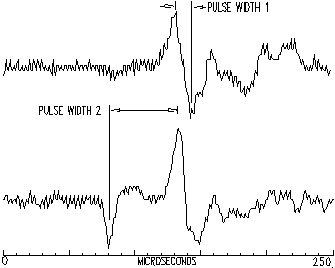
A unique pulse shape change has been observed. Pulse width is measured from the maximum amplitude of the first signal excursion to the maximum amplitude of the next opposite polarity excursion. During the less severe (lower activity) portion of a weather formation duration, the predominate pulse shape follows the lower curve. A unipolar pulse precedes a bipolar pulse which (for the curve shown) was sensed as a negative polarity event. As the activity increases, the unipolar pulse disappeared leaving a bipolar pulse (upper curve). This pulse was sensed as a positive event.
 The upper curves of the previous figure confirms this pulse shape effect. The two curves are plotted in a stacked format (top curve added to the lower curve value). The pulse width data is collected in four pulse width categories. The middle two width categories are not plotted since the total data in these categories is considered insignificant. Reviewing these curves, it is obvious that the pulse width changes from the longest width to the shortest width without a significant number of events in either of the middle width categories. This pulse width change also explained the accompanying polarity change.
The rapid polarity/width change is only been observed during the buildup or decay of a weather formation. Generally, once a formation has increased to a relatively constant activity level, the pulse width will remain short. Some formations have been observed to produce a slow polarity change over several hours. The pulse width data indicates a short pulse during that change. At this time, it unknown if this effect is caused by another pulse shape or actual pulse polarity change. Polarity change across a peak is also unresolved at this time.
Summary
The timing of the electromagnetic energy pulses from weather systems may provide a key to the prediction of the severity of those systems. The project described in this paper generates data which indicates a relationship between severe weather and the relative timing between bursts of electromagnetic energy emanating from the weather system. With the limited data collection (single monitoring location), it is difficult to determine the potential of this technique.
Polarity and pulse shape factors have not been fully evaluated. The repeating nature of the patterns suggest that there must be conditions which causes the effect. Observations appear to support a relationship with the weather severity.
Future Plans
Obviously, additional effort will be necessary to prove or disprove the usefulness of this technique for severe weather prediction. This technique is presented at this time to describe the current state of the project. To fully evaluate this system, more monitoring stations will be needed to provide better coverage and triangulation information.
These monitoring sites should be located on a grid with 300 to 500 miles spacing. The site equipment would operate unattended and communicate with a central analysis facility. The site equipment would consist of the two foot diameter loop antenna system, amplifiers, and computer (small PC). In many cases, this could be accommodated in the top floor of an existing building. The sites should not require attention that could not be handled through the communication link. Local readout and/or analysis equipment could be included but would not be necessary for the network to function. The communication link requirement are minimal. In general, less than a 1000 bytes of data would be transmitted each 5 minutes. During very severe weather, the data rate from selected sites would increase by several times. A standard telephone line can supply this requirement.
With additional monitoring locations, the personnel at the analysis facility will be able to selectively analyze the data from the site with the best "view" e.g. only one weather system within the usable range. Pattern analysis from one or more sites can be used to determine the severity of the weather system. When necessary, data would be available from other sites to locate an occurrence by triangulation. Since more and better quality data would be available at this analysis facility, one would expect to find additional patterns or signatures which relate to severe weather.
PC Monitor description
Hardware drawings, etc.
Question or comments?
Please contact
Dick Fergus W9DTW
rfergus@theramp.net
Revised 11-13-98