
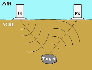
 GROUND PENETRATING RADAR uses
high frequency radio waves to acquire subsurface information from a small antenna which is
moved slowly across the surface of the ground.
GROUND PENETRATING RADAR uses
high frequency radio waves to acquire subsurface information from a small antenna which is
moved slowly across the surface of the ground.
Energy is radiated downward into the subsurface, then reflected back to the receiving antenna, where variations in the return signal are continuosly recorded, or viewed on a color monitor. this produces a continuous cross-sectional "picture" or profile of shallow subsurface conditions.
These responses are caused by radar wave reflections from interfaces of materials having different electrical properties. Such reflections are often associated with natural geohydrologic conditions such as bedding, cementation, moisture and clay content, voids , fractures, and intrusions, as well as man made objects.
Depth of penetration is highly site specific, being dependent upon the properties of the site's soil and rock. Generally, better overall penetration is achieved in dry, sandy or rocky areas, poorer results are obtained from a considerable depth in saturated materials. Radar penetration from 1 to 10 meters is common.
As described in the preceeding section, the radar video record shows soil strata and other features much as they would appear to an observer looking at the wall of a vertical trench. In general, soils and underlying clays, gravel and other materials are usually distributed in well defined, horizontal strata. Any trench or excavation dug into the ground would disturb these well-defined layers. This disruption of the horizontal layers is known as the "trenching effect", and is normally seen in the radar data wherever there is a buried pipe, cable, or other excavation which has been backfilled with randomly mixed material.
In areas where sufficent ground penetration is achieved, the radar method provides a powerful tool. it offers the highest resolution, and provides continuous spatial sampling and can be carried out very rapidly. Its continuous video format permits rapid semi-quantitative interpretation for in-field analysis.
Back to the Radar Data Service Homepage